
Gps Parcela mobile app

GPS navigation to your land parcel
App Features:
- Identification of land parcels, cadastral parcels.
- Display your land parcels on a map on your smartphone.
- View the distance between the smartphone and the land parcel.
- View your current smartphone location on the map.
- Read the current GPS coordinates.
- Improved accuracy of the current GPS coordinates reading.
- Create a land parcel by entering the coordinates.
- Update the entered coordinates.
- Download the cadastral parcel coordinates from our web server
- Transformation from reference coordinates to Gps (WGS84) coordinates
- Calculation of land parcel area and boundary line lengths.
- Save the land parcel files in your local smartphone storage.
- Language support for English, German, Italian, Croatian, Slovenian, Serbian, Czech, Slovak, Polish, Spanish, Portuguese, French.
- Support for the coordinate systems and geoportals in the following countries: Austria, Belgium, Bosnia and Herzegovina, Bulgaria, Croatia, Czech Republic, Estonia, France, Germany, Italy, Latvia, Lithuania, Montenegro, North Macedonia, Poland, Portugal, Serbia, Slovakia, Slovenia, Spain, Switzerland and Europe.
- Backup and restore.
Features available on Android
- Centimeter GPS accuracy with RTK correction using the built-in NTRIP client
- Precise navigation to the parcel corners
- Support for RTK GNSS receiver
Gps Parcela Pro mobile app

Precise GPS locating, Land measurement,
Division of land parcel
The Gps Parcela Pro app has all the features of the Gps Parcela app and additional advanced features:
- Centimeter GPS accuracy with RTK correction using the built-in NTRIP client
- Precise navigation to the parcel corners
- Support for RTK GNSS receiver
- Precise points recording and measurement
- Division of land parcel
- The parallel guidance lines used in precision agriculture
- Route recording
- List of visible satellites
- Coordinate transformation between coordinate systems
To precisely locate the parcel corners, the Gps Parcela Pro app applies the RTK method to correct the accuracy of GPS coordinates using a Bluetooth GNSS receiver and Internet access to a network of reference stations.
You can perform land measurement to get the coordinates of the corner points of your land parcel or coordinates of any other point on the land parcel with an accuracy of 1 cm.
In this case too, the application applies the RTK method and the NTRIP client.
The division of the land parcel is one of the most important features of this app, which is important in several cases.
The division of land parcel is necessary when the co-owners want to divide their land parcel (forest, field, meadow) only and mark the land without officially registering the division in the cadaster.
Another case of division occurs when the owner plans to subdivide his large building plot for sale into several smaller parts and wants to make an analysis of possible division solutions.
Gps Nautika mobile app
GPS Sea Navigation
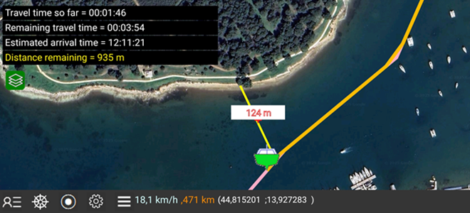
The Gps Nautika app is intended for all skippers of motorboats and sailboats who want to use GPS for sea navigation.
This is important in case you, as the skipper, know the departure point and the arrival point, but do not know the exact route you will sail.
For safe sea navigation, it is necessary to plan the route you will navigate using GPS.
As a first step, you need to get the coordinates from the map or you can enter the coordinates for each route point directly into the app.
In the second step, you can open the planned route file and start the navigation process. Track recording will also be turned on.
You will sail towards your destination along the planned route, following your current position on the smartphone screen.
You can also check the distance to the coastline at any time.
Gps Parcela Drone mobile app
Drone Mission Waypoints
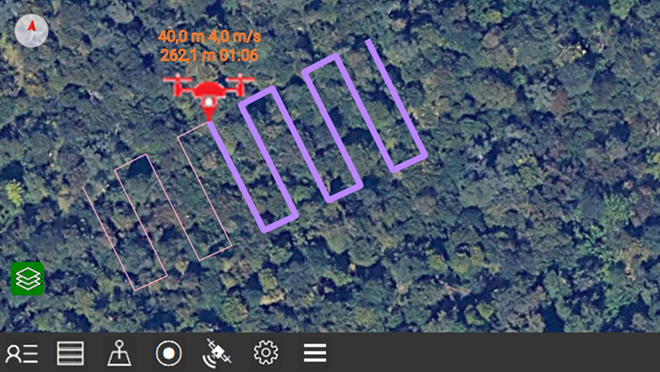
The Gps Parcela Drone app is primarily intended for all private landowners and all real estate, precision agriculture and forestry professionals, who want to monitor their land parcels using the drone's camera and automatically generated waypoints.
The app can automatically generate drone mission waypoints that will be within your land parcel for the following mission types: parallel lines, spiral lines, concentric lines and parcel boundary lines.
The created mission waypoint file can then be exported as a Google KML file.
For the purpose of this app, the land parcel is any land having its own boundaries defined by corners. Most often, the land parcel can be a cadastral parcel, but it can also be part of an agricultural plot or any other land plot for drone flight. The corner points are defined with GPS (WGS84) coordinates known as latitude and longitude.
The corner points can be defined in other coordinate reference system.
You can also define corner points using Google Maps where you create a map of the land parcel as a polygon and then import the Google KML file into the app.
RTK GNSS Receiver

Vanis RTK receivers
The Gps Parcela and Gps Parcela Pro apps allow connection to the RTK receiver using Bluetooth, and connection to the CORS - reference GNSS stations network using Internet.
In this way, The Gps Parcela and the Gps Parcela Pro apps enable centimeter GPS accuracy with RTK corrections.
The Spanish electronic company ArduSimple produces Vanis RTK receivers for VANIS d.o.o. Croatia
You can get Vanis RTK receivers directly from the ArduSimple web store.
> Vanis RTK Handheld Surveyor Kit, recommended for Gps Parcela app
> Vanis RTK Calibrated Surveyor Kit, recommended for Gps Parcela Pro app


